About
About Tibet
Where is Tibet? Why should you help Tibet regain its freedom? What is Tibet like? What really happened when China invaded Tibet?
Here is where you can find the answers to some of your questions. Arm yourself with the knowledge you need to be an intelligent freedom fighter!
- Size
- 2.5 million sq. km.
- Capital
- Lhasa
- Population
- 6 million Tibetans and an estimated 7.5 million Chinese, most of whom are in Kham and Amdo
- Language
- Tibetan (of the Tibeto-Burmese language family)
- Provinces
- Amdo, Kham & U-Tsang
- Bordering Countries
- India, Nepal, Bhutan, Burma, China
- National Flag
- Snow lions with red and blue rays. Banned in Tibet.
- Religious Leader
- The 14th Dalai Lama
- Political Leader
- Sikyong (Prime Minister) Penpa Tsering
- Government in Exile
- Parliament (Central Tibetan Administration)
- Government in Tibet
- Communist (People's Republic of China)
- Relationship with the PRC
- Colonial
- Legal Status
- Occupied
- Economy
- Tibetans: predominantly in agriculture and animal husbandry. Chinese: predominantly in government, commerce, and the service sector.
- Average Altitude
- 14,000–16,000 ft.
- Highest Mountain
- Chomo Langma (Mt. Everest), 29,028 ft.
- Average Rainfall
- Varies widely. In the west, 1mm in Jan. to 25mm in July. In the east, 25–50mm in Jan. and 800mm in July.
- Average Temperature
- July 58°F (14.5°C); Jan. 24°F (-4.5°C).
- Mineral Deposits
- Borax, uranium, iron, chromite, gold
- Major Rivers
- Mekong, Yangtse, Salween, Tsangpo, Yellow, Indus, Ganges, Irrawaddy
- Major Environmental Issues
- Rampant deforestation in Eastern Tibet, poaching of large mammals, grassland desertification, permafrost degradation, unregulated and destructive mining and resource extraction
- Staple Food
- Tsampa (roasted barley flour)
- National Drink
- Salted butter tea
- Animals
- Wild yak, Bharal (blue) sheep, Musk deer, Tibetan antelope, Tibetan gazelle, Kyang (wild ass), Pica
- Birds
- Black necked crane, Lammergeier, Great crested grebe, Bar-headed goose, Ruddy shelduck, Ibis-bill
Where Is Tibet?
Tibet lies at the center of Asia, with an area of 2.5 million square kilometers. Encircled by the Earth’s highest mountains, Tibet is a vast, arid plateau with an average altitude of 14,000 feet above sea level. The Tibetan plateau has unique and exceptional ecosystems.
The headwaters of Asia’s major rivers originate on the Tibetan plateau, which supply 85% of the population of Asia with water — approximately 47% of the world’s population.
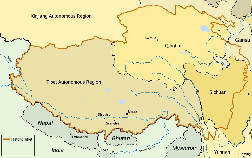
Tibet is comprised of the three provinces of Amdo, Kham, and U-Tsang. Amdo is now split by China into the provinces of Qinghai and part of Gansu. Kham is largely incorporated into the Chinese provinces of Sichuan, Gansu and Yunnan, and U-Tsang, together with western Kham, is today referred to by China as the Tibet Autonomous Region (TAR).
The TAR comprises less than half of historic Tibet and was created by China in 1965 for administrative reasons. It is important to note that when Chinese officials and publications use the term “Tibet” they are referring only to TAR.
Tibetans use the term Tibet to mean the three provinces described above, the area traditionally known as Tibet before the invasion in 1949–50.
Despite over 60 years of Chinese occupation of Tibet, the Tibetan people refuse to be conquered and subjugated by China. The present Chinese policy — a combination of demographic and economic manipulation and discrimination — aims to suppress the Tibetan issue by changing the very character and the identity of Tibet and its people.
Today, Tibetans are outnumbered by Chinese in their own homeland.
Take Action for Tibet
For more information and action material, check out our Action Kit.
Visit the Action Kit